- 2024年-02月-16日:唐土名胜图会.初集.6卷(88P)
- 2024年-02月-16日:唐土名胜图会.初集.5卷(75P)
- 2024年-02月-16日:唐土名胜图会.初集.4卷(78P)
- 2024年-02月-16日:唐土名胜图会.初集.3卷(87P)
- 2024年-02月-16日:唐土名胜图会.初集.2卷(54P)
- 2024年-02月-16日:唐土名胜图会.初集.1卷(62P)
- 2024年-01月-13日:彩图版《中国国家地理百科全书》6、青海、宁夏、新疆、香港(106P)
- 2024年-01月-13日:彩图版《中国国家地理百科全书》5、四川、贵州、云南、西藏(122P)
- 2024年-01月-13日:彩图版《中国国家地理百科全书》4、湖北、湖南、广东、广西(106P)
- 2024年-01月-13日:彩图版《中国国家地理百科全书》3、浙江、安徽、福建、江西(106P)
- 2024年-01月-13日:彩图版《中国国家地理百科全书》2、内蒙古、辽宁、吉林、黑龙(106P)
- 2024年-01月-13日:彩图版《中国国家地理百科全书》1、总论、北京、天津、河北(105P)
- 2024年-01月-13日:《中国景色·彩图版》作者:单之蔷(385P)
- 2023年-12月-16日:宣大山西三镇图说.三卷.明.杨时宁编.景明万历时期刊本.玄览堂丛书.1941年(303P)
- 2023年-12月-16日:渝城图.约绘于1850-1900年.法国国家图书馆藏(12P)
- 2023年-12月-16日:行宫座落图.扬州名胜图.江南名胜图.四册.清代刊本(110P)
- 2023年-12月-16日:异域图志.一卷.剑桥大学图书馆藏.明刊孤本(206P)
- 2023年-09月-24日:泛槎图.含续泛槎图等.全集.清张宝撰.道光时期羊城尚古斋刊刻(500P)
- 2023年-09月-24日:法军远征在埃及考察研究作品集之埃及自然史板画(253P)
- 2023年-09月-21日:新镌海内奇观·六册(60P)
- 2023年-09月-21日:新镌海内奇观·五册(59P)
- 2023年-09月-21日:新镌海内奇观·四册(63P)
- 2023年-09月-21日:新镌海内奇观·三册(72P)
- 2023年-09月-21日:新镌海内奇观·二册(47P)
- 2023年-09月-21日:新镌海内奇观·一册(66P)
- 2023年-06月-14日:百幕大未解之谜(181P)
- 2023年-06月-14日:雍和宫集(1~20)(68P)
- 2023年-04月-25日:故宫宽幅照片(48P)
- 2023年-04月-14日:世界美术全集:建筑卷(97P)
- 2023年-04月-08日:中国建筑艺术史 (下册)(665P)
- 2023年-04月-08日:中国建筑艺术史 (上册)(584P)
- 2023年-04月-08日:建筑装修与装饰·中国建筑艺术全集 24(242P)
- 2023年-04月-05日:宅第建筑 4 南方少数民族·中国建筑艺术全集 23(330P)
- 2023年-04月-05日:宅第建筑 3 北方少数民族·中国建筑艺术全集 22(219P)
- 2023年-03月-27日:游遍世界(172P)
- 2023年-03月-27日:宅第建筑 2 南方汉族·中国建筑艺术全集 21(333P)
- 2023年-03月-27日:佛教建筑(2)(南方) (丁承樸)·中国建筑艺术全集(319P)
- 2023年-03月-23日:游遍中国(172P)
- 2023年-03月-16日:宅第建筑1 北方汉族·中国建筑艺术全集 20(325P)
- 2023年-03月-16日:风景建筑·中国建筑艺术全集 19(320P)
- 2023年-03月-10日:私家园林·中国建筑艺术全集 18(328P)
- 2023年-03月-10日:皇家园林·中国建筑艺术全集 17(249P)
- 2023年-03月-05日:道教建筑·中国建筑艺术全集 15(318P)
- 2023年-03月-05日:会馆建筑·祠堂建筑·中国建筑艺术全集 11(299P)
- 2023年-03月-02日:书院建筑·中国建筑艺术全集 10(320P)
- 2023年-03月-02日:坛庙建筑·中国建筑艺术全集 9(333P)
- 2023年-02月-28日:泰晤士世界历史地图集(360P)
- 2023年-02月-27日:清代陵墓建筑·中国建筑艺术全集 8(280P)
- 2023年-02月-27日:明代陵墓建筑·中国建筑艺术全集 7(328P)
- 2023年-02月-25日:元代前陵墓建筑·中国建筑艺术全集 6(313P)
- 2023年-02月-25日:桥梁、水利建筑·中国建筑艺术全集 5(334P)
- 2023年-02月-24日:古代城镇·中国建筑艺术全集 4(317P)
- 2023年-02月-24日:宫殿建筑(3) 沈阳·中国建筑艺术全集(312P)
- 2023年-02月-24日:宫殿建筑(2)(北京)·中国建筑艺术全集(311P)
- 2023年-02月-24日:宫殿建筑(1)(北京)·中国建筑艺术全集(247P)
- 2023年-02月-09日:镇江胜境图暨乾隆御题诗刻.清高宗弘历撰并书.民国拓本(6P)
- 2023年-02月-07日:西湖佳景.湖上扶摇子辑.彩色图绘套印本.1750(22P)
- 2023年-02月-04日:亚细亚大观.照片.亚细亚写-真大观社编.1935-1942(396P)
- 2023年-01月-29日:韩国舆地图.金鸿圭模绘.1893(13P)
- 2023年-01月-29日:《廣輿圖》二卷【明】朱思(237P)
- 2023年-01月-27日:古今历代中华地图(16P)
- 2023年-01月-17日:江戸絵図.鍬形紹真画(6P)
- 2023年-01月-13日:中國博物館藏畫.上海博物館藏畫(128P)
- 2023年-01月-12日:万国博覧会日本館仮図案(25P)
- 2023年-01月-03日:江苏至北京运河全图(13P)
- 2022年-12月-31日:東京真画名所図解.井上探景画(22P)
- 2022年-12月-29日:岸圃大观.乾坤.明彭汝楠辑.崇祯11刊(37P)
- 2022年-12月-24日:Matrícula de tributos.墨西哥.贡品录(32P)
- 2022年-12月-24日:北京皇城图(3P)
- 2022年-12月-17日:海底世界 珊瑚礁和鱼类的天堂(368P)
- 2022年-12月-15日:第八册(清时期)中国历史地图集(142P)
- 2022年-12月-15日:第七册(元 明)中国历史地图集(193P)
- 2022年-12月-15日:第六册(宋辽金)中国历史地图集(131P)
- 2022年-12月-15日:第五册(隋唐五代)中国历史地图集(150P)
- 2022年-12月-14日:第四册(南北朝)中国历史地图集(108P)
- 2022年-12月-14日:第三册(魏晋)中国历史地图集(91P)
- 2022年-12月-14日:第二册(秦汉)中国历史地图集(101P)
- 2022年-12月-14日:第一册(先秦)中国历史地图集(92P)
- 2022年-12月-10日:中国地方志辞典之二(405P)
- 2022年-12月-10日:中国地方志辞典之一(400P)
- 2022年-12月-04日:[典藏国家地理:中国版(下)].龚勋.全彩版(113P)
- 2022年-12月-04日:[典藏国家地理:中国版(中)].龚勋.全彩版(113P)
- 2022年-12月-04日:[典藏国家地理:中国版(上)].龚勋.全彩版(113P)
- 2022年-11月-23日:地理龙穴扼要 第10册(133P)
- 2022年-11月-23日:地理龙穴扼要 第9册(147P)
- 2022年-11月-23日:地理龙穴扼要 第8册(109P)
- 2022年-11月-23日:地理龙穴扼要 第7册(119P)
- 2022年-11月-22日:地理龙穴扼要 第6册(101P)
- 2022年-11月-22日:地理龙穴扼要 第5册(97P)
- 2022年-11月-21日:地理龙穴扼要 第4册(157P)
- 2022年-11月-21日:地理龙穴扼要 第3册(87P)
- 2022年-11月-20日:地理龙穴扼要 第2册(156P)
- 2022年-11月-20日:地理龙穴扼要 第1册(128P)
- 2022年-11月-07日:世界经济地理(245P)
- 2022年-11月-03日:环球国家地理百科全书之七(214P)
- 2022年-11月-03日:环球国家地理百科全书之六(400P)
- 2022年-11月-03日:环球国家地理百科全书之五(400P)
- 2022年-11月-03日:环球国家地理百科全书之四(400P)
- 2022年-11月-03日:环球国家地理百科全书之三(400P)
- 2022年-11月-03日:环球国家地理百科全书之二(400P)
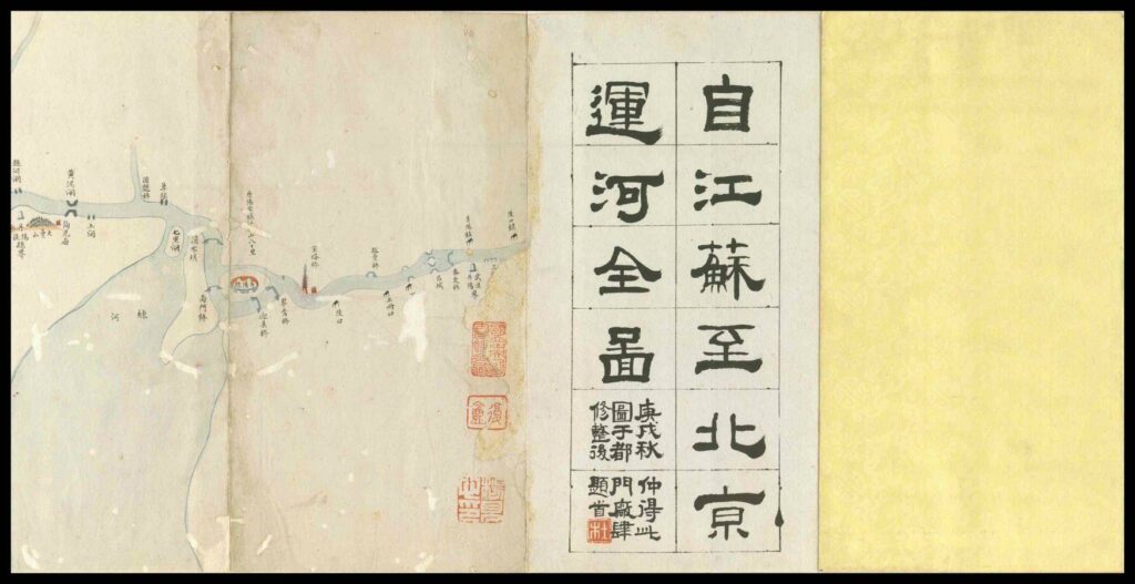
《江苏至北京运河全图》由连续长页制成后折迭为经折装,高 24.1 厘米,宽 13 厘米,共 21 折。卷首附有以墨笔隶书手题的图名。此图于清代(1644–1911 年)刊印,但作者与出版日期未知。左下有三行题记云:“庚戌秋仲得此/图于都门厂肆/修整后题首”。图上还盖有多个章印,包括“杜”字白方、“复盦”朱方 以及“杨见心”白方,这些印章很可能指作品之前的收藏者。这幅地图以世界上最长的人工运河“京杭大运河”(简称“大运河”)为主题。自隋代 (581–618 年)以来,大运河促进了中国都市中心区经济市场的繁荣。从唐代至清代,它作为贯穿中国南北的主要交通动脉,一直是运输粮食和其它商品到北京的要道。这条便利的交通动脉也让皇帝得以巡视江南地区。在清代,康熙皇帝和乾隆皇帝就曾12 次南巡,有一次还到过杭州。本图首尾有残损,江南一段已佚缺。图中所示的运河不是自杭州起,而是自江苏武进县附近之陵口镇起始,一路蜿蜒北进,但只到山东省的临清州界止,才刚越黄河,尚未进入河北,距北京还有一段相当长的距离。这幅地图绘制精细,沿途各支流、湖泊、山林、城池、桥梁、寺院、宝塔、神庙、沟闸、河堤岸、沙洲、斗门,乃至各地距离等等,均一一注明。有些支流密如蛛网,是常年在运河上航行的漕运客难以想象的。这类地图向来较少刻本传世,因此非常珍贵。
The Complete Map of the Canal from Jiangsu to Beijing is made of continuous long pages and then folded into a folded package, with a height of 24.1 cm and a width of 13 cm, totaling 21 folds. At the beginning of the volume, there is a title of calligraphy in ink. This picture was printed in the Qing Dynasty (1644 – 1911), but the author and publication date are unknown. There are three lines of inscriptions on the bottom left: “Gengxu Qiu Zhong obtained this/Pictured in Dumen Factory IV/The title after repair”. There are also several seals on the drawing, including the white side of the word “Du”, the white side of the word “Fu” Zhu and the white side of the word “Yang Jianxin”. These seals probably refer to the previous collectors of the works. This map is themed on the longest man-made canal in the world, the Beijing Hangzhou Grand Canal (the Grand Canal for short). Since the Sui Dynasty (581 – 618), the Grand Canal has promoted the prosperity of the economic market in China’s urban centers. From the Tang Dynasty to the Qing Dynasty, as the main transportation artery running through the north and south of China, it was always the main road to transport grain and other commodities to Beijing. This convenient transportation artery also enabled the emperor to inspect the Jiangnan region. In the Qing Dynasty, Emperor Kangxi and Emperor Qianlong made 12 southern patrols, and once visited Hangzhou. The head and tail of this drawing are damaged, and a section of Jiangnan has been lost. The canal shown in the picture does not start from Hangzhou, but from Zhilingkou Town near Wujin County, Jiangsu Province. It winds its way northward, but only ends at the boundary of Linqing Prefecture, Shandong Province. It has just crossed the Yellow River and has not yet entered Hebei. It is quite a long distance from Beijing. This map is finely drawn, and all tributaries, lakes, mountains, forests, cities, bridges, temples, pagodas, temples, sluice gates, river banks, sandbars, Doumen, and even the distances of various places along the way are indicated one by one. Some tributaries are as dense as cobwebs, which is unimaginable for water transport passengers sailing on the canal all the year round. This kind of map has never been handed down in printed form, so it is very precious.


Record记录 Region地理 13P 江苏至北京运河全图
历史上的今天 ( 13 ):
- 2024年-01月-03日:Metaphysics玄学:四柱阴阳经
- 2024年-01月-03日:Metaphysics玄学:卜文命学
- 2024年-01月-03日:Metaphysics玄学:卜文后二十五期资料,吐血推荐!
- 2024年-01月-03日:Metaphysics玄学:卜文八字期刊
- 2024年-01月-03日:Metaphysics玄学:八字中的婚姻信息
- 2024年-01月-03日:Metaphysics玄学:12长生的扩展内涵
- 2024年-01月-03日:Metaphysics玄学:《四柱陰陽經》1-6期輔導資料
- 2024年-01月-03日:Metaphysics玄学:兰台妙选
- 2024年-01月-03日:Metaphysics玄学:黄勇智八字命理学(大纲版)
- 2024年-01月-03日:Metaphysics玄学:《滴天命理新论》张绍金
- 2024年-01月-03日:Metaphysics玄学:卜文命学新集
- 2024年-01月-03日:Metaphysics玄学:八字强弱鉴定法
- 2024年-01月-03日:News新闻:2024年1月3日新闻简报(国内国际)
可点 ➠ 2023年-01月-03日 ➠ 67 s ➠ ♥ 0

